
 |
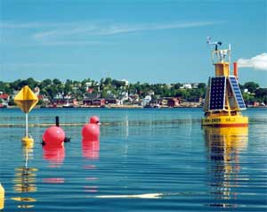
| From left: the buoy with meteorological sensors fitted on top, the optical sensor (behind pink ball) and radar reflector gather information in Lunenburg Bay. (Penny Kuhn photo) |
If you’ve seen a strange yellow buoy bobbing around Lunenburg Bay and wondered what it does, here’s your chance.
On Friday, scientists with the Centre for Marine Environmental Prediction (CMEP) will be at the Fisheries Museum of the Atlantic in Lunenburg and out on the water to talk about the instruments they use, the information they're gathering and what it's being used for. Called “The Underwater Weather: Looking Beneath the Surface of Lunenburg Bay,” the open house goes all day, from 9:30 a.m. to 5 p.m.
“We’ve been on the water monitoring Lunenburg Bay since 2003 and there’s some pretty neat stuff going on,” says Stéphane Kirchhoff, CMEP’s project manager.
|
Principal investigators for the $7-million project are John Cullen and Alex Hay, professors with �鶹��ý��Դ’s Department of Oceanography. In the five years the centre has been operational, dozens of undergraduate and graduate students have helped by monitoring equipment and analyzing data.
“The weather in the ocean is intimately affected by the weather in the atmosphere,” says Mr. Kirchhoff. “Our monitoring and research should allow us some forecasting capabilities in terms of currents, circulation, wave height, storm surges and biological growth.”
CMEP’s research is aided by some pretty cool instruments: three coastal buoys that measure meteorological conditions; acoustic pods that sit on the ocean floor and measure currents through the water column; and optical sensors that look at sunlight and how it penetrates the ocean. The buoys are powered by solar panels and transmit data every half hour directly to.
There are also two land-based meteorological stations: one on Cross Island that measures fog, and another at Battery Point at the entrance of Lunenburg Harbour that gauges air pressure, air temperature, wind speed, wind direction and precipitation. As well, there’s an offshore buoy located 25 kilometres from Halifax that takes measurements in the water column, including levels of carbon dioxide.
The information gathered from these instruments has a number of practical applications. For example, measurements from our sensors and national and international observing systems help to make forecasts of extreme events – information that could have left decision-makers better equipped to deal with weather disturbances such as Hurricane Juan.